
Return to main Vanishing B.C. page Return to home page
Page last updated November 24, 2003
© Michael Kluckner

|
Sketches from 2003: The Rolla Pub, at the corner of the Sweetwater Road and the Rolla Road. Pouce Coupe is 15 km or so due south--that is, over the hill in the distance. Rolla is a hamlet north of Dawson Creek about 10 km west of the Alberta border. It is on the checkerboard grid of roads and grainfields that is a westward extension into BC of the standard prairie grid, and part of the Peace River Block settled after the First World War. Today, with farmers and oil workers ranging easily over its paved roads and connections to the outside world as efficient as anywhere, it is hard to imagine how difficult life was before the Northern Alberta Railway arrived in Dawson Creek in 1931. |
|
"Flooded farmhouse" on Sweetwater Road – the yellow grain covers the land like floodwater, turning copses of aspen into islands and peninsulas and marooning abandoned farmhouses, their gables and roofs all that is visible above the waving sea. |
It is sitting atop a sea of oil and gas. Every mile or two today, you come upon an oil rig occupying perhaps an acre of turned-over brown earth. Usually, a small derrick with a red-painted top occupies the middle of the site, with a couple of portable structures and a handful of pickup trucks nearby. I didn't see any of the bobbing "iron ants" typical of Alberta oilfields, but maybe just missed them. The natural gas extraction and pumping stations are equally common and unobtrusive, an acre or so of valves and pipes, thick and curled like macaroni, behind high chain-link fences. Often, they sit in clearings in the aspen bush along the roadsides – for example, I sat at the entrance gate to one while painting the "flooded farmhouse" on Sweetwater Road. |
|
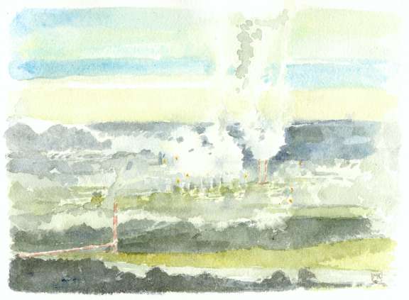
A misty morning on the Peace River, about 9 a.m. on a September day promising to become fine, with smoke and steam from the gasworks at Taylor mixing with the ground fog rising from the fields. The yellow flares, hydrogen sulphide burning off as part of the "sweetening process" of the natural gas, eerily punctuate the blue-grey murk. In 1957 at Taylor, the crossing point of the Peace River on the Alaska Highway south of Fort St. John, Westcoast Transmission Company completed its natural gas line from the Peace to the USA and established its main processing plant. It is one of a few spots in the Peace that is a true "industrial landscape" – the equivalent of the pulp mills or smelters that dominate towns elsewhere in the province (another is the WAC Bennett dam complex). Duke Energy bought out Westcoast Transmission and now runs the gas processing plant. Press Release March 14, 2002: "CHARLOTTE, N.C. Duke Energy (NYSE:DUK) significantly enhanced an already strong position in the North American energy market today with the closing of the previously announced acquisition of Vancouver, British Columbia-based Westcoast Energy Inc. The transaction, valued at approximately US$8 billion based on cash, stock consideration and debt assumed, is expected to be accretive to Duke EnergyÕs earnings." Duke Energy Annual Report 2002: "The British Columbia Pipeline System (BC Pipeline) consists of the field services division, with more than 1,840 miles of gathering pipelines in British Columbia, Alberta, the Yukon Territory and the Northwest Territories, as well as 22 field compressor stations; four gas processing plants located in British Columbia at Fort Nelson, Taylor, Pine River and in the Sikanni area northwest of Fort St. John, with a total contractible capacity of approximately 1.8 Bcf of residue gas per day; and three elemental sulphur recovery plants located at Fort Nelson, Taylor and Pine River. The pipeline division has approximately 1,740 miles of transmission pipelines in British Columbia and Alberta, as well as 18 mainline compressor stations." |