Return to main Vanishing B.C. page Return to home page
Page last updated February 15, 2021
© Michael Kluckner
|
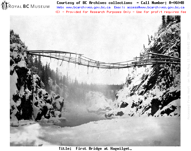
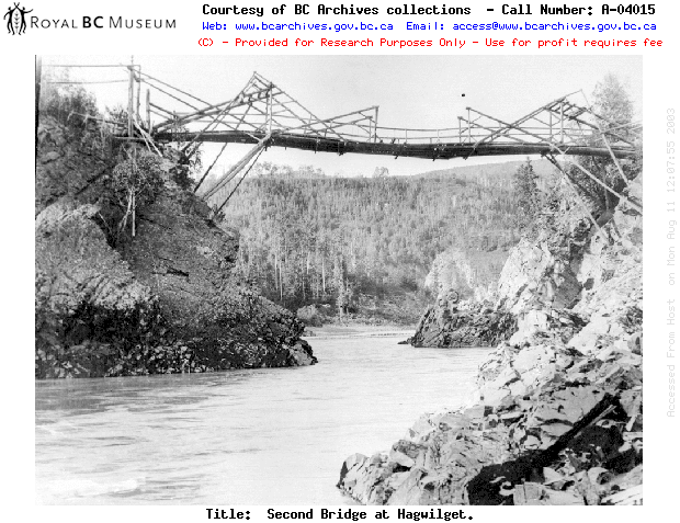
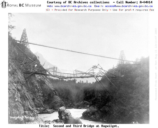
Although the 1930 Hagwilget highway bridge—one of the last single-lane bridges from the early years of auto travel—is a historic structure in its own right, it replaced an ingenious Indigenous-built suspension bridge across the spectacular canyon of the Bulkley River near the old riverboat terminus of Hazelton in northwestern BC. The people at Hagwilget (meaning “gentle or quiet people”), a village that is part of the Gitksan-Wet’suwet’en traditional territory and was considered to be "the outpost of Catholicism in the North" by writer Wilfrid Playfair, had devised a bridge of poles and rope generations before White settlement began in the 1860s. When the Collins Overland Telegraph (aka the Siberia-Alaska Telegraph) was abandoned following the successful laying of the Atlantic cable in 1866, the Hagwilget reinforced their bridge with some of the cable left lying in the woods. The nearby Gitksan village of Kispiox, renowned for its totem-pole carvers, is the site of the blockhouse that was the end of the operating section of the line. The telegraph line was later resurrected to provide a connection with Dawson City during the gold-rush years of c. 1900. See http://collections.ic.gc.ca/skeena/telegraph_trail.htm Photographic evidence indicates that this is in fact the fourth bridge across the canyon: the original a pure suspension bridge; the second a combination of cantilever and suspension which would be the one Playfair wrote about; the third, which appears to be a copy of the original Alexandra Bridge-type of suspension bridge built by the Royal Engineers in 1862 and which must have been built c. 1912-14 and removed c. 1930; and the extant bridge. The upgrading of the 140-metre-span bridge in 1990 by engineers Buckland & Taylor Ltd. increased its load capacity and won the firm an award of excellence from the Consulting Engineers Association of Canada. Five kilometres past the bridge, ‘Ksan Historical Village today interprets traditional Indigenous culture. |
The photos below are all by undetermined photographers
and are dated 1872, c. 1894, and c. 1914
| Hagwilget band: http://www.bcfn.org/profile/hagwilget.htm
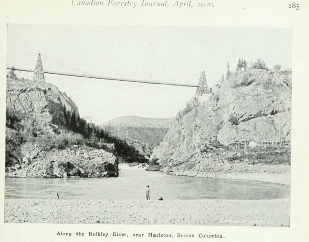
From Hedley Auld in Winnipeg, 2021: A 1920 photograph of
the Third Hagwilget Bridge.Photo was published in Canadian
Forestry Journal, available online at archive.org.
From Ingo Oevermann, 2012: I believe the 'third'
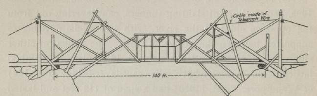
bridge over the Hagwilget Canyon is the current Note from Eric Sakowski, 2009: I am working on a website to document the Highest Bridges of North America and the world. As I am gathering information on bridges that are above 190 feet or so in height, I will also be showing the background of each bridge including past structures that crossed in the same location. As I was looking to include the first two lower bridges as well as the upper, higher bridges that would be the main focus of my website, I was curious about what years the 1st and 2nd bridges might have been built and destroyed. While this information might not exist, I was wondering if you had seen a drawing of the 2nd bridge I am sending you from the 1916 book "Bridge Engineering" by H.G. Tyrrell.
While he gives little information on when the bridge was up and his drawing is not an exact match to photos, it does show the span length of 140 feet which shows someone had a good look over of the bridge. I was also curious if you know why the small center section shown in the drawing does not seem to be a part of the 2nd bridge in the photo. I was also curious if there is still currently a road or trail down to the site of the first two bridges. Finally, I would like to know if the 3rd bridge was just a
footbridge or a true road bridge. While another website has 9
feet for the deck width, I am not so sure this would have been
wide enough for autos, especially given the string like
appearance of the deck in photos. Also, I can't imagine with the
train line having only reached that region just 4 years earlier
that there would have even been any automobiles of any sort in
the region - the bridge seemed to be just a crossing for locals
who would hardly have had the money or foresight to build a
sturdy bridge capable of a thousand pound automobile. So my
question is whether it was a footbridge or a true road bridge.
Maybe a photo with a car would change my mind. For the record,
it would seem the 3rd bridge was approximately 240 feet high
while the current bridge is 252 feet from deck to water. Note from Mrs. Rosa E. M. Clowater, 2009: My uncle, Clarence Lewis Dimock (now deceased), built two of the suspension bridges across the canyon. He was a Civil Engineer in charge of building the right of way for the Canadian National Railway. The first one, I believe, was for foot traffic only, but the second (over which I have ridden) was for vehicles. In 1920 he became Municipal Clerk for the new town of Smithers. Between then, and 1945 when he retired and moved to Webster's Corners in the Fraser Valley, he built the main road bridge (washed out in 1966) across the Bulkley between Smithers and Telkwa, as well as laid out the roads around the area. Framed pictures of the Hagwilget bridges were given to him when he retired. One of those pictures hung on the wall at his daughter's home in Lumby until her death. If you can't get a picture through the Bulkley Valley Museum at Smithers you might have some luck contacting his son, Arthur Dimock, also a civil engineer, now retired and living on Estline Road, Victoria.
|